Schooldays
Did you go to school in Walthamstow? Want to see pictures?
Pictures and stories here!
13 Dec 2011 - Maps:
Hi Daniel, Mick Gilbey has posted a map of 1933 and on it are some proposed road development in our area. I am now wondering whether your map shows the proposed N.Circular and that our mystery road was never built, because it encroached on the forest, at least when they built the N.Circular they had the decency to skirt the forest and not like the next generation plough their way through it, they could quite easily tunnelled as they did at Bell Common, Epping. There was a particularly nice glade of silver birch trees, which many local artists used to paint, sadly all gone....
What a coincidence you had an aunt in Beacontree Ave: I only lived 4 roads away. I think our road will remain a mystery and its time to move on. kindest regards
Tony JONES
[Private Reply]
[Public Reply]
12 Dec 2011 - Public reply to Mike Gilbey:
Hello Michael, Your email is well researched and you make a convincing explanation of the 'mystery' road that, I am sure, is correct.
Respects
Bill BAYLISS
[Private Reply]
[Public Reply]
11 Dec 2011 - Mistery Map - Public Reply to Rodney Silk:
I think the solution to the mystery road alongside Beacontree Avenue can be found on the 1908 map of London, at this address: [http://mapco.net/bart1908/bart11b.htm].
It appears to be a wide trackway large enough for a vehicle. I cannot tell from the map whether it was tarmaced or not but I would not think so. The map then shows the wide track petering out to a footpath which doubles back to Bellvue Road. In 1908 it appears that Pentire Road including the intersecting roads to Bellvue Ave had not been built. Becontree Avenue also terminated at Bellvue Ave at that time.
On another 1933 map, contained in an article I wrote [read it here], Pentire Road had still not been built. This same wide track (mystery road) appears on the 1933 map as well. Clearly when the North Circular Road was built alongside Beacontree Avenue, all traces of this track would have disappeared.
Daniel's mystery map does show the outline of Pentire Road although I suspect many roads have been omitted for the sake of clarity and replaced a red shaded areas indicating urban occupation. If the map in my article was drawn just before 1933, then Daniels map must be after that time.
Mick GILBEY
[Private Reply]
[Public Reply]
11 Dec 2011 - Mistery Map:
I can concur with Tony Jones that the road opposite Beacontree Avenue linking Forest Road with the Woodford New Road, as shown on the map of Epping Forest posted in November 2009, is a mystery. My first recollection of the North Circular Road, from the Crooked Billet roundabout to the Waterworks corner, was immediately post war and I can confirm that at that time Beacontree Avenue was not part of the A406 as shown on the map. It ran along side the A406 for its length and houses were only built on one side of Beacontree Avenue facing the A406. Having looked on Google Earth this is still the case today. I attach a copy of the Ordnance Survey map dated 1964 which shows the North Circular Road before its route was altered to line up with its more direct journey to link up with the new M11. The area of the original route was returned back to forest land. The Survey Map shows that the North Circular Road did indeed run along side Beacontree Avenue and was not part of it. This map also shows that no road exists opposite Beacontree Avenue linking Forest Road with the Woodford New Road. My Godfrey map No.78.01 of Highams Park & Hale End dated 1914 shows that Wadham Road, from the Crooked Billet, had a natural route across the railway line(yes it was a level crossing) and into what is now called Hale End Road. Sky Peals Road was a minor road going straight ahead at the junction with Hale End Road. My Victorian map of 1888 shows that Wadham Road was originally named Blind Lane. The Godfrey map shows Beacontree Avenue bordering the forest and joining with Pentire Road. Unfortunately this 78.01 Godfrey map does not cover the area of Forest Road and the Woodford New Road and I suspect this would be included in the adjoining map No.78.02 of Woodford dated 1915. Perhaps this map would show if the mystery road was in place at this time.
Kind regards,
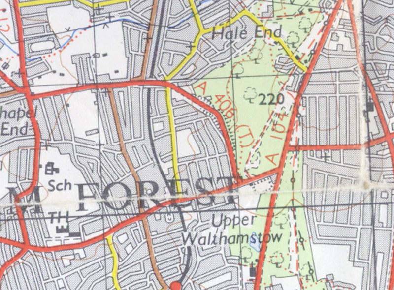
Ordnance Survey Map 1964
Rodney SILK Private Reply Public Reply
01 Dec 2011 - Maps: Hi Daniel - I have just been looking at an enquiry you made on 25th Nov. 2009, showing part of a map of Epping Forest of which you were trying to date. The map is unusual as it shows a road which, to my knowledge, has never existed! This is opposite Beacontree Ave and seems to link Forest Rd with Woodford New Rd. It certainly wasn't there when I was a child at the end of the 40's. The map shows tram lines which I dont believe ran in W'stow after the war, where the road is marked Beacontree Ave I don't believe this to be correct, as Beacontree Ave ran parallel to the North Circular and was never part of it; the yellow road marked Beacontree Ave which joins Wadham Rd is most certainly the N.Circular which was built around 1930, although the railway line which is at Wadham Bridge is shown to go over the road and not under... of course there was a level crossing there before the building of the N.Circular sometimes known as the Arterial Rd. If you have had any further response to this I would be interested to know. Thank you very much for the time and effort that you must put in to this website, as I am part of the generation holding the baton, we are the only personal link to the past. You may be aware of a firm called alangodfreymaps.co.uk. Regards
Tony JONES
Private Reply
Public Reply
28-Nov-2009: Walthamstow Map. Hello! The map shows the Whips Cross Hospital as West Ham Infirmary. The Infirmary was built between 1900-1903 and the name was changed to Whips Cross Hospital in 1918. So my educated guess is that the map can be dated to a period between 1903-1917. Hope this helps.
Regards.
Eb Vawda
Private Reply
Public Reply
27-Nov-2009: Walthamstow Map. I was checking out the WM site this evening as I tend to do every week or so, just in case there is a question I can help answer, actually I've had a fair success rate in that department just recently. Anyway this brings me nicely on to your request regarding the map.
Obviously most W'stow maps are easily roughly dated by the railways, so that puts this one into the 20th century for starters, I do have many old maps myself, but this one appears a little vague and hard to date exactly, probably hence the reason you ask in the first place. Upon first inspection I thought that I had it dated pretty accurately, I usually tend to date them by the growth of the Warner Estate. Carr Road (which is on the map) was built in 1902 but the rest of the roads that followed on the Llyods Park development aren't there, namely Fleeming 1907, Elphinstone 1912 etc, so at first I thought I had solved it, and with a little bit more study I would narrow it down to within a year or two at least.
However having given it a closer look I now find that it omits most of the roads built in Victorian times, namely all the Village, but it seems to replace any developed areas with shaded pink, which in turns seems to suggest that all the park estate would have all been built. To be honest given how basic it is in detail, you wouldn't get lost if you used it today, nothing much has changed apart from the re-routing of the North Circular.
So to conclude my thoughts and coming up with an educated guess, rather ironically my decision is made by Beacontree Ave, I recall that photo you sent me and our discussion at the time. If you look at the end part of the road where it meets Forest Road, you will notice that there is the aforementioned pink shaded area, the very first are Edwardian houses (about a row of ten built around 1908), after that they become 1930's build. Going further down the road to the small road on the left (part of Belle Vue Road, it now runs fully into Hale End) there also appears to be development. This was originally the site of Belle Vue House, a rather grand mansion complete with lake, I'm sure you've read about it during your research at some time. Anyway it wasn't knocked down until 1937. So I'm guessing that coupled with the fact that even this basic map wouldn't miss out a building of such grandeur and that the shaded area appears to have already made its way a good half way down, I would suggest that the map is actually post war, given that no maps would have been printed between 1936/45. Based also on the part construction of the Risings Estate that is my conclusion, and I'm pretty well sure I am correct, I think the map would probably have been one of the first ones to be produced after the war, although possibly based upon a map which would have been surveyed during the late 1930's
I'd be interested to hear if you get anymore suggestions, whether to prove or disprove, it makes interesting debate. Regards
Michael Wood
Private Reply
Public Reply
25-Nov-2009: I've found an old "Epping Forest" Map and here is the section of it showing the Walthamstow area. There is no date on the map (1920's?), so if anyone can date it (or have old maps to post)... please let me know. Thanks.
Daniel email

Walthamtow Map - 1920??

Daniel J Quinn
Editor of Walthamstow Memories

Did you go to school in Walthamstow? Want to see pictures?
Pictures and stories here!
Have you lost trace of your family members who lived in Walthamstow? Leave a message and you might
get feedback from our visitors!
Or perhaps you can help someone in their search?
Are you seeking a friend you've lost touch with? Have a look at this page and you might find him/her? Or perhaps you can help someone in their search?
This site constantly grows thanks to the memories that you, our visitors, send in.
If you find that it's a pleasure reading, please consider writing too!